A few days ago the National Oceanic and Atmospheric Administration issued a press release discussing why it changed its prediction for Atlantic hurricane season. The agency is now calling for “above normal” activity. The rationale is that record warmth in Atlantic basin waters should offset El Nino conditions, which can often suppress hurricane activity. August is typically the month when tropical cyclone activity ramps up, and this year is no different. To make matters worse, Major Hurricane Hilary has formed in the Eastern Pacific basin. Parts of California and the southwestern U.S. are currently within the cone of uncertainty. Here are three things that you need to know right now.
The “good and bad news” of Hurricane Hilary – Part 1
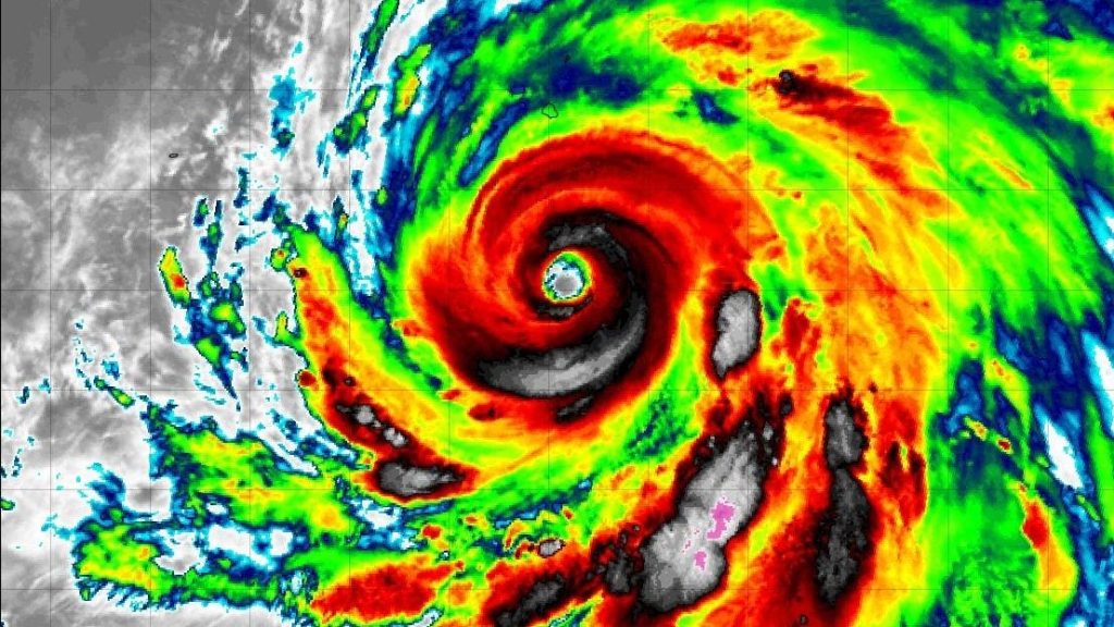
Before I discuss the parade of potential storms in the Atlantic basin. Let’s focus on Hurricane Hilary. At the time of writing, it is a Category 4 major hurricane. Tropical Storm Warnings and Hurricane Watches have been issued for parts of the Baja California penisula in Mexico. Warm sea surface temperatures and a favorable environment have allowed the storm to intensify. That’s the bad news. I would not be surprised if some additional strengthening happened on Friday. The infrared satellite imagery (map below) from Friday morning shows a well-developed hurricane and a clearly defined eye.
As I poured over the latest meteorological data and read the Friday morning discussion from the National Hurricane Center, I did find some “good news.” Forecasters noted, “In addition, oceanic heat content will be dropping significantly in 24-36 hours, and it’s likely that Hilary’s large wind field will mix up cooler water ahead of the arrival of the center.” The lack of warmer waters and even the Baja California peninsula should aid in the weakining process. Remember, high ocean heat content is the fuel supply for these tropical systems.
The “good and bad news” of Hurricane Hilary – Part 2
It is always weird to see places like California and Arizona within the “cone of uncertainty.” This brings me to the second set of “good news, bad news” with Hilary. The storm will likely be significantly weaker by the time it moves inland, but there are still potential hazards with the remnant low pressure system. The National Weather Service is expecting three to six inches of rain in parts of the Southwest and West by the weekend and into early next week. Some places could see almost a foot of rainfall. With this type of rainfall and terrain, flooding is always a concern.
On the other hand, the region has also been baking for weeks under oppressive heat and dry conditions, so the rainfall is certainly needed. The heaviest core of rainfall will likely be just east of Los Angeles and immediately to the west of Las Vegas. However, the flood risk is possible throughout the region. Some models suggest a hard left for the remnant low after landfall, which could prolong rainfall in places like southern California so that will need to be watched closely.
Multiple areas to watch in the Atlantic Ocean and Gulf of Mexico
In the Atlantic basin, at least four areas are being monitored. In the short term, the system in the far eastern portion of the basin has the highest probability of further development. However, the other systems could develop within five to seven days. Meteorologist Craig Setzer posted some important context on X, the platform formely know as Twitter.
Though a few days away from potential development, I am definitely keeping a sharp eye on the system in the Gulf of Mexico. It is close to the U.S. mainland and has some chance of development. With sea surface temperatures running hot this year, it is wise to keep your guard up for any potential systems. The sea surface temperature anomalies (differences from an average state) indicate plenty of high octane “fuel” available for any storm that pulls up to the pump. And remember, the peak of the Atlantic hurricane season is still a few weeks away so buckle up.
Read the full article here


