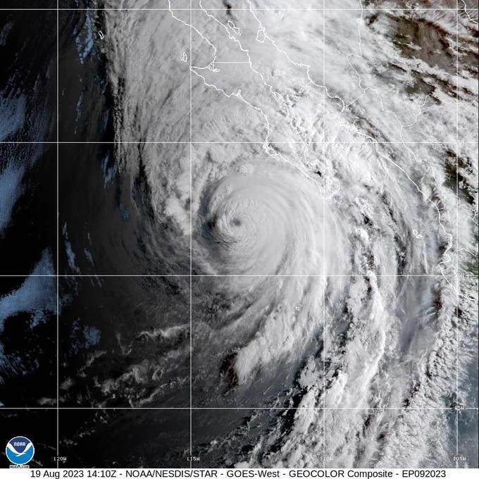
I wrote an article yesterday noting that the first Tropical Storm Watch in California’s history had been issued. We now have the first Tropical Storm Warning in the state’s history too. A Tropical Storm Warning means such conditions are expected within 36 hours. Hurricane Hilary, a Catetory 3 storm at the time of writing, continues to plow towards Mexico and the southwestern U.S., including California. This region is not as experienced with tropical systems so here are three “must know” things for the folks out west, and they could have life or death implications.
The relative irrelevance of hurricane category
I have seen numerous headlines saying that a Category 4 hurricane is headed towards California. I find that information to be misleading and potentially dangerous. It will likely not even be a hurricane by the time it traverses the Baja Peninsula and reaches the U.S. Hurricane Hilary is a major hurricane right now, but that will be irrelevant to people in California and the Southwest. My biggest concern for the U.S. is the high-impact potential of Hilary as a Tropical Storm or even an unnamed low pressure system. Meteorologist Taylor Trogdan hits the nail on the head in the X post below. He warns that this region of the country has very little experience with this type of tropical rainfall, which can be quite intense and inundating. By the way, I hope you catch the sarcasm in his post.
The National Hurricane Center’s public messaging on Saturday afternoon says, “Hilary is expected to produce storm total rainfall amounts of 3 to 6 inches, with isolated maximum amounts up to 10 inches, across portions of the northern Baja California Peninsula through Sunday night. Flash and urban flooding, locally catastrophic, is expected, especially in the northern portions of the peninsula.” For the southwestern U.S. it is a similar story. The discussion continues with this warning – “Rainfall amounts of 3 to 6 inches, with isolated amounts of 10 inches, are expected across portions of southern California and southern Nevada.”
The words “dangerous” and “catastrophic are also mentioned. Even outside the highest core of rainfall, 1 to 3 iches of rainfall will still lead to localized and potentially significant flash flooding. Large urban areas like Los Angeles, Las Vegas, and San Diego are in the moderate to high flood risk regions. For context, Las Vegas averages just under 4 inches of rain for the year. It might get close to that with this storm. Places like Death Valley could receive one to two years worth of rainfall in a single day, according to CNN.
To make matters worse, flooding is not simply a function of what falls from the sky. The urban impervious surfaces like parking lots and roadways reduce infiltration and increase surface runoff. In more elevated terrain, extreme rainfall will likely cause mudslides and other related hazards. To top it off, tropical storm force winds will certainly be possibly, particulary at higher elevations. How many people in this part of the country have experience with this type of rainfall coupled with winds gusting over 39 mph? Exactly. California will likely start experiencing tropical storm winds on Sunday.
Impacts are not dots or lines on a map
The eastern U.S. and Gulf of Mexico region are used to dealing with hurricanes and tropical storms, yet many people still do not understand the cone of uncertainty and the expansiveness of impacts. Rainfall, wind, surge, and even potential tornado impacts will extend well beyoind those black dots in the graphic above. In the projected rainfall totals map below, extreme rainfall totals are distributed along and well beyond the storm center. If you take anything away from this story, it should be: Focus on impacts, how expansive they may be, and for how long.
Water is the most deadly aspect of tropical systems not winds
Hurricane winds are telegenic. You often hear hurricanes and tropical storms discussed in terms of their category or winds. How many times have you seen reporters leaning sidewides during hurricane coverage? However, study after study confirm that water is the deadliest aspect of these systems. The storm surge and inland freshwater flooding are often discounted or underestimated. Heck, I see people drive through flooded roadways all of the time. Because this region may not be used to the intensity of rainfall possible with this storm, I am further amplifying this message.
Read the full article here


