Earlier today, Hurricane Watches and Warnings were issued for much of the Baja Peninsula region of Mexico. A Tropical Storm Watch has also been issued for southern California. It is the first time ever that the National Hurricane Center has issued a tropical storm watch for the state of California. The tropics are active, but I am certain most people did not have a hurricane approaching California on their bingo card. Hurricane Hilary reached major category status earlier today and is moving northward. In a previous Forbes.com article, I discuss the details of the hurricane from a meteorological perspective. Herein, I put on my climatological hat.
This may be confusing to some people because the 1939 Tropical Storm did make landfall in California. Professor Cary Mock is a geographer and climatologist at the University of South Carolina. He specializes in climatological reconstruction of past tropical hazards. He told me by direct message, “ (in) September 1939 a tropical storm, near hurricane strength, made landfall in southern California.” From his logs, he found waves greater than twenty-nine feet.
Mock also pointed out that because the region had been suffering through triple-digit degree heatwave, beaches were packed. Unfortunately, the storm caught many people by surprise because there were no weather satellites in 1939. As with the Galveson storm a few decades earlier, fatalities (roughly 45 to 100) from the storm are likely undercounted. Mock went on to say, “this storm was the only landfalling historic storm in southern California’s recorded history.”
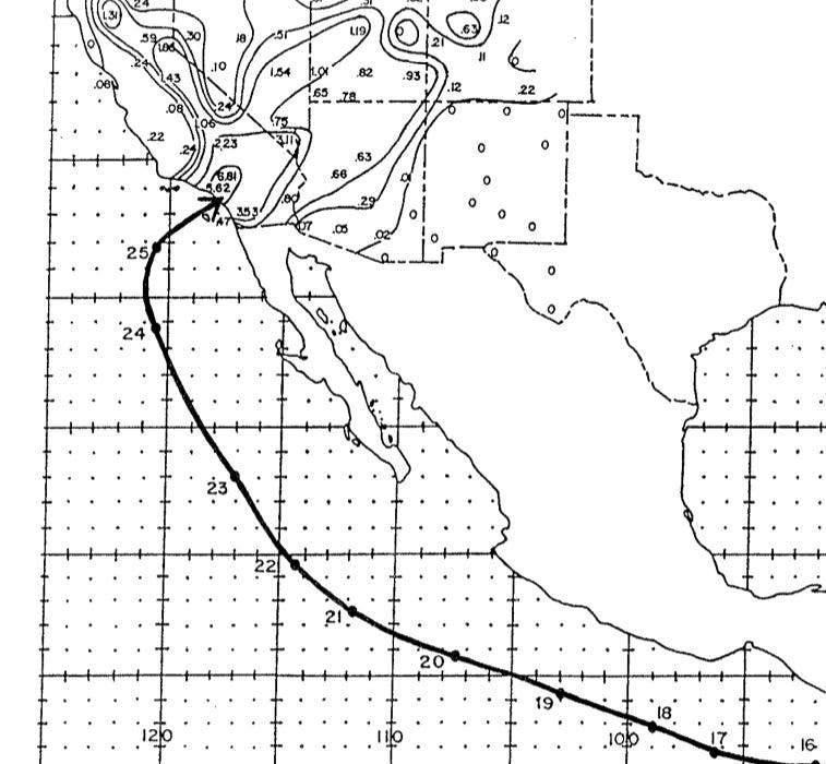
This storm, also known as El Cordonazo, The Lash of St. Francis or the 1939 Long Beach tropical storm, is ranked by the Desert Research Institute as one of California’s top fifteen weather events of the 1900s. According to its website, the September 1939 Tropical Storm lost, “hurricane status shortly before moving onshore south of Los Angeles (San Pedro) at tropical storm strength, the system packing torrential rains and sustained winds of 50 mph drenched Los Angeles with 5.62 inches of rain in a 24 hour period.” I found an obscure NOAA report referenced by Professor Mock, which reproduced the storm track. Remember, the type of track information in the satellite era is a treasure trove compared to 1939.
Ok, let’s deal with the question about the claim of “first tropical storm watch in California history.” Well, this is an easy one. In 1943, a joint hurricane forecast unit was shared by the Weather Bureau, Air Corps, and Navy in Miami, Florida. Later in 1956, this effort would evolve into the National Hurricane Information Center and ultimately the National Hurricane Center. There were no National Hurricane Center issued tropical storm watches in 1939 because there was no National Hurricane Center.
Tomer Burg is a weather expert and doctoral candidate at the University of Oklahoma. His post in responce to a rather ill-posed comment on the social media platform called X provides additional context.
Read the full article here


